THIS IS THE MAPLINKS PAGE FOR MAPS CONNECTED TO 
THE LEVERSTOCK GREEN CHRONICLE. 
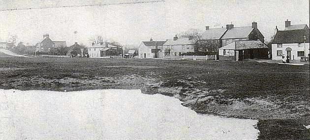
 No history of a location is complete without maps.  

This website, linked to the Leverstock Green Chronicle by Barbara Chapman, contains any maps relevant to the history of Leverstock Green.  Each page contains a separate map and any supporting text.  Click on the map title or group below to take you to the map you require.  

If you have any queries about any of these maps please contact Barbara Chapman via the CONTACT ME BUTTON, and she will be pleased to reply.
 Map Showing Area of Study for The Leverstock Green Chronicle

GENMAPS/HERTFORDSHIRE this is a link to the GENUKI rootsweb site with downloadable copies of numerous old maps of Hertfordshire, dating from 1577~1885  NB many of these maps are far from acurate, so need to be compared with information already known.

 Map Showing the Parishes and Hundreds of the Leverstock Green area prior to 1850

Map Showing Principle Dwellings & Lanes to be found in the Leverstock Green Area 11th-17th centuries.

1996 Map showing Roman & Pre-Roman Features in the wider Leverstock Green area.

Map Showing Listed Buildings & Arhaeological Features  around Westwick Row as of October 2000

Map Showing Known Medieval Infrastructure in the Leverstock Green area.

Map Showing Medieval Fieldnames in Leverstock Green 

 Map showing the Extent of Lawrence Farm, Green Lane, 16th century to mid 19th century.

Map Showing Medieval Manor of Market Oak alias Levestistock Greene.

Map Showing area of Hedgerow Surveys around Westwick Row/Pancake Lane

Map extract from Benjammin Hare's map of Gorhambury 1634 (Great Tithe Barn of Westwick.)

Map showing the Extent of the Manor of Westwick.

Map showing "Harps" field, Blackwater Lane

Map Showing the holdings of Margaret Wooton of Woodwells (14th century).

Map Showing extracts from Dury & Andrews map of Hertfordshire, 1766

Map showing proposed Area of Archaeological Significance within St. Alban's jurisdiction in the Leverstock Green area - (end 2002)

Map Showing Area of Archaeological Significance ( No 61) in Leverstock Green 2003 (Dacorum Borough Council)

1634 map ~ HALS document D/EV/P1 - being a map of the Gorhambury Estate drawn up in 1634 by Benjamin Hare. Includes blow-up of Westwick Row section.

1696 maps ~ - HALS document IA68 - Being a Survey of the lands of Sir Samuel Grimston 1696   includes sketch maps of many local farms.

1768 map ~HALS document D/EV/P2 - being a map of the Gorhambury Estate drawn up in 1768. This map measures approximately 18'x24' at a scale of aprox 9" to the mile. Includes details from Estate Book, and individual sections of the map.

ORDNANCE SURVEY EXTRACTS:
N.B. Maps published within the last 75 years cannot be published here because of copyright legislation.  A full range of the local OS maps up to the present day and in all scales can be seen in the Hemel Hempstead Local Studies Library or at HALS or visit the OS website. (Click here)

PLEASE NOTE THAT I  NOTICED SEVERAL ERRORS IN THE OS MAP TITLES & DATES. I  THEREFORE  REPUBLISHED THE MAPS  HAVING CORRECTED THE ERRORS IN MARCH 2003.  ONE OR TWO ADDITIONAL MAPS HAVE BEEN ADDED.


1877 6in:1 mile Ordnance Survey Map showing Leverstock Green Area

1877 6":1 mile OS map of Leverstock Green Area, West to East.

1877 6":1 mile OS Map of the northern Leverstock Green Area (Coxpond to Saracen's Head - now Adeyfield.)

1877 Ordnance Survey 25inches: 1 mile map of  Bennetts End 

1877 Ordnance Survey 25inches: 1 mile map of  central Leverstock Green .

1877 Ordnance Survey 25 inches:1 mile map of Westwick Farm and Pancake Wood

1883 6": 1 mile OS map - north central LG

1883 6": 1 mile OS map - Buncefield north

1883 6": 1 mile OS map - Woodwells north

1883 6": 1 mile OS map - south central LG

1883 6": 1 mile OS map - central SE LG

1883 6": 1 mile OS map - Gorhambury

1883 6": 1 mile OS map - Hillend to Kettlewells

1897 Ordnance Survey 25inches: 1 mile map of  central Leverstock Green.

1897 25 inch:1 mile OS Map extract showing Woodlane End Farm, Woodlane End brickworks and Maylands Wood.

1897 Ordnance Survey 25 inches to 1 mile Map of Bennetts End 

1897 Ordnance Survey 25inches: 1 mile map of  Tile Kiln Farm & brickworks. 

1897 Ordnance Survey 25inches: 1 mile map of  Tile Kiln Lane. 

1897 Ordnance Survey 25inches: 1 mile map of  Tile Kiln Lane western end. 

1897 Ordnance Survey 25inches: 1 mile map of  Tile Kiln Lane, eastern end. 

1897 Ordnance Survey 25 inches: 1 mile map of  Hobbs Hill Wood area. 

1897 Ordnance Survey 25 inches to 1 mile Map of Leverstock Green & Chambersbury 

1898 25": 1 mile OS map of Pancake Lane ( 2nd Edition)

1924 OS 25inches: 1 mile map of the Central Leverstock Green area.

1924/1925 Ordnance Survey 25 inches to 1 mile Map of Hill Farm & Belconey 

1924/1925 Ordnance Survey 25 inches to 1 mile Map of Bennetts End Farm & West Tile Kiln Lane area.

1924/1925 Ordnance Survey 25 inches to 1 mile Map of Bennetts End (north) 

1924/1925 Ordnance Survey 25inches: 1 mile map of  Tile Kiln Farm & Hobbs Hill Wood area. 

1924/1925 Ordnance Survey 25inches: 1 mile map of  Central Leverstock Green 

1924/1925 Ordnance Survey 25 inches to 1 mile Map of  Leverstock Green from Northend Farm to The Dells 

1924/1925 Ordnance Survey 25 inches to 1 mile Map of Chambersbury & Pancake (house) area  Leverstock Green 

1925 Edition 6":1 mile map of Central LG


This page was last updated: October 24, 2018
Tell a friend about this page
Add this page to your favorites.
THE LEVERSTOCK GREEN CHRONICLE - click here to go to the main index page for The  Leverstock Green Chronicle